http://acorncentre.co.uk/cookie-policy/ Drone & Aerial Photography

  • Photography & Video
    • Aerial Photography & Video Services
    • Interior & Exterior Architectural Photography
    • Photoshoot Example | Interior / Exterior & Aerial Photography
    • Evan Petty Photography Purchase Wall Wraps, Prints and More!
    • Event Photography & Video
  • Industries
    • Construction Industry
      • Drone Vs Airplane FAQ
      • Warehouse Aerial Update Example
      • Drone Aerial Construction Progress
      • Drone Aerial Construction Progress Update – USA Parkway in Nevada
      • Construction Aerial Progression 2014
      • Drone & Airplane Construction Examples
    • Real Estate – Commercial and Residential
      • Shopping Center Aerial Views
    • Ranch Aerial Video & Photography
      • Aerial Photo & Video For Your Ranch Listing
    • Solar & Energy Aerial Photography
      • Gallery Solar & Energy
    • Mining Industry
    • Engineering
      • Gallery Bridge Construction
    • Insurance / Investigation
    • Verticals
  • Gallery Locations
    • Reno & Sparks Areas
      • Reno Downtown
      • University of Nevada
      • Verdi & Sommersett
      • South Reno
      • North Reno | Stead
      • Washoe Valley, NV
      • Stead Area
      • Sparks Areas
    • Tahoe Reno Industrial Center
    • Burning Man Aerials – Black Rock City, Nevada
    • Lake Tahoe | Truckee | Incline Village | Tahoe City
      • Lake Tahoe Resort Photoshoot
      • Tahoe National Forest
    • Carson City | Minden | Gardnerville | Washoe Lake
    • Fernley & Fallon and Outlying Areas
      • Virginia City, NV Aerial Views
      • Lake Pyramid
      • Elko, Nevada
      • Battle Mountain, NV
      • Austin, NV Aerials
      • Eureka, NV Aerials
      • Ely, Nevada Aerials
    • Mammoth Lakes | June Lake | Bishop
    • San Francisco Aerials At Night
    • Other Areas
      • Hoover Dam / Lake Mead
      • Phoenix Arizona
    • Ground Photography
      • Industrial Plant
      • Real Estate Interior & Exteriors
      • Construction Site Photography
    • Nevada Google Earth Interesting Sites
  • Blog
  • About
    • Aerial Imaging Photography & Video
    • Aerial Imaging Testimonials
  • Contact

Interesting Google Earth Images – Nevada

http://hillaryaugustine.com/book-now-water-package/ September 15, 2014 by evan 1 Comment

http://thebeginningfarmer.com/distillers-grains-twice-as-nice-or-not/ Nevada has an interesting history with unique sites, some of which can only been seen using Google Earth. Here are some noteworthy images I have found. You will need to open Google Earth and paste the latitude/longitude locations below.

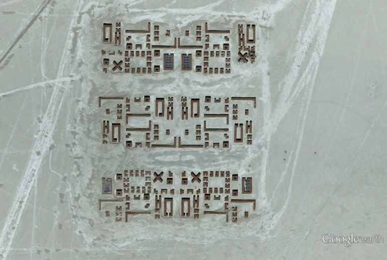
Someone is possibly sending a message from the desert floor. Strange symbols. Google Earth location : 39°52’36.27″N, 118°23’54.08″W
Yes, a mock submarine in the desert likely used for testing pilots. Notice the bomb marks. Google Earth location : 39°54’27.32″N, 118°19’20.18″W
State historic remains of a United States Army Fort Churchill and waystation on the Pony Express and Central Overland Routes – dating back to the 1860s. Google Earth location : 39°17’33.53″N, 119°16’16.07″W

What causes these shapes? Is this natural or caused by some kind of experiment? Formed from lava? …or by Area 51 tests? Google Earth location : 38°23’0.47″N, 116° 4’9.11″W
The site of the “Spirit Cave” where in 1996 previously found mummies were determined to be 9,400 years old, older than any previously known North American mummy. Google Earth location : 39°25’6.46″N, 118°37’16.85″W
This would be an interesting drive, it looks like an earthquake split the highway. The truth is Hwy 722 is actually fine. Google Earth location : 39°15’22.82″N, 117°44’35.82″W

Did you know you can follow the Pony Express Trail using Google Earth? This is a tiny portion of the Pony Express Trail from the Shoshone Range across the north Dry Lake in the Smith Creek Valley. Google Earth location : 39°22’27.20″N, 117°26’51.10″W
A nuclear test in 1962 resulted in this large crater. According to Wikipedia, “The explosion created fallout that affected more US residents than any other nuclear test.” Google Earth location : 37°10’36.76″N, 116° 2’46.58″W
This is a bombing target in a restricted part of Nevada Google Earth location : 37.563838,-116.85115

Or is this a lost city? Very curious. Google Earth location : 39°44’2.53″N, 119° 2’13.30″W
The BREN TOWER is a huge 1,486ft tall used to experiment with dangerous gamma rays and neutrons. The very tall tower is now gone. Next Google update… no tower. Google Earth location : 36°46′50.23″N 116°14′36.9″W
This 1865 Mormon settlement is normally deep under Lake Mead’s water, but it is now visible. Google Earth location : 36°28’0.94″N, 114°22’18.00″W

where can i purchase Clomiphene  

http://thmiii.com/episodes/4  

Filed Under: Blog Updates, Google Earth Interesting Sites

Recent Aerial Photo & Drone Video

Ranch Photographer Aerial Drone Nevada

Aerial Photo & Video For Your Ranch Listing

Your Listing Has A Great Story - Let Me Help You Tell It! I can … more

Evan Petty Photography

Purchase Wall Wraps, Prints and More!

Need an Artistic Aerial wall wrap or print? Aerial wall wraps and … more

Tilting Construction Aerial Drone Photographer

Drone Aerial Construction Progress

Walls Up! Tilting Walls on a Construction Site! We can shoot ground … more

Lake Tahoe Resort & Property Photoshoot | Aerial & Architectural Photography and Video

Our most impressive photography & video service is to shoot both … more

Commercial Photographer Reno Tahoe Industrial Center

New Construction Photographer in Tahoe Reno Industrial Center in Nevada

… more

Commercial Warehouse Aerial

Commercial Real Estate Aerials

Aerial Photography for Commercial Real Estate Views A close-in view … more

Mt Rose Nevada Aerial Photographer

Mt Rose Aerial Views Including Opening Ski Season 2022

I flew over Mt Rose to get aerial views during opening ski season. … more

Purchase Photography Prints

Purchase Prints & More!

Purchase Evan Petty Photography (Aerial Imaging) prints for your … more

What Our Customers Are Saying

"Once we met with Evan, we immediately cancelled our other meetings with his competitors. From start to finish Evan worked tirelessly to meet our needs, even when we didn't know what we wanted. Our locations were remote and large. Evan captured them perfectly and on time. The end results surpassed our expectations. We are happy to say we will never use anyone else."
-Stephen Echeverria 2018

Sign Up Now! – Monthly Aerial Newsletter

Our monthly aerial gallery newsletter has unique aerial pictures of places in Nevada, Arizona and parts of California. You will find it fascinating!

Recent Posts

  • Spring Construction Aerial Update Promotion March 20, 2023
  • Aerial View of Palisades and Olympic Village at Lake Tahoe March 17, 2023
  • Construction Aerial Photography March 6, 2023
  • Aerial Construction Update Images March 5, 2023
  • Aerial Photography of Sierra Tree Colors in Autumn January 10, 2023
  • Virginia Lake in Reno, NV Aerial View January 2, 2023
  • Photography Images of New 7-11 Construction in Reno, NV January 2, 2023
  • Grand Sierra Resort in Reno, NV Aerial View January 2, 2023
  • Reno Public Market Aerial Photography and Exteriors January 2, 2023
  • New Construction Photographer in Tahoe Reno Industrial Center in Nevada January 2, 2023
  • Aerial View of Clouds & Mountains in Nevada January 2, 2023
  • Lenticular Clouds Forming Over the Eastern Sierras December 23, 2022
  • Agricultural Crop Circle Aerial View December 17, 2022
  • Mt Rose Aerial Views Including Opening Ski Season 2022 December 4, 2022
  • Aerial View of Hwy I-580 Galena Creek Bridge in Reno, NV December 4, 2022
  • Downtown Reno Aerial View June 30, 2022
  • Tahoe Reno Industrial Center Photography April 9, 2022
  • Mt Rose Aerial Showing Great Lake Tahoe View March 27, 2022
  • Stunning Storm Clouds & Light Rays at Mt Rose March 20, 2022
  • RED Development Aerial Photography in Reno, NV March 15, 2022
  • Virginia City Aerial View March 13, 2022
  • Aerial View of Incline Village @ Lake Tahoe February 13, 2022
  • Aerial View of Sparks, NV January 24, 2022
  • Construction Aerial Photography Example! January 24, 2022
  • Aerial View of Snowy Sierra Mountain Range January 24, 2022
  • Colorful Trees Reno, NV January 22, 2022
  • Sierra Storm 2022 January 22, 2022
  • Cold Springs – North Reno Aerial Photography October 2, 2021
  • Downtown Reno and Midtown Aerial View July 4, 2021
  • Purchase Prints & More! June 9, 2021
  • Downtown Truckee, CA Aerial View June 6, 2021
  • Wide Aerial View Reno, NV March 26, 2021
  • Tahoe Reno Industrial Center (TRIC) Aerial Views 2021 March 21, 2021
  • Hug High School Aerial Construction Progress March 14, 2021
  • Aerial View of houses in Reno, NV March 14, 2021
  • Victorian Square Aerial View March 14, 2021

Aerial Locations

In addition to Northern Nevada and California locations, I can provide you with edited aerial video and customized photography in many parts of the US. I am connected with other aerial videographers & photographers worldwide to assist us with your project. I look forward to hearing from you.

Need Photography or Video for Your Listing or Project?

Need custom aerial shots in a hurry? Contact me today about your aerial or commercial photography project, the contact form is ideal. If you prefer you can call or text my cell 775- 84.six- 85.nine.eight. I look forward to hearing from you.

About Evan

Aerial photographer since 2001. Nevada is home with wife and 2 kids. Coffee drinker, reader of history, guitar player and forest explorer near Tahoe. Always up for a good story. Front page aerial image is South Lake Tahoe after sunrise in 2023.

Copyright © 2023 · Agency Pro Theme on Genesis Framework · WordPress · Log in